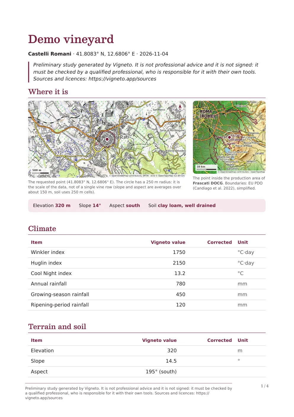
The first page of a Report generated with demonstration data.
Inside the Report
From a point on the map to a complete story.
Every item brings together the data, its meaning and its source. The images below come from the same test Report.
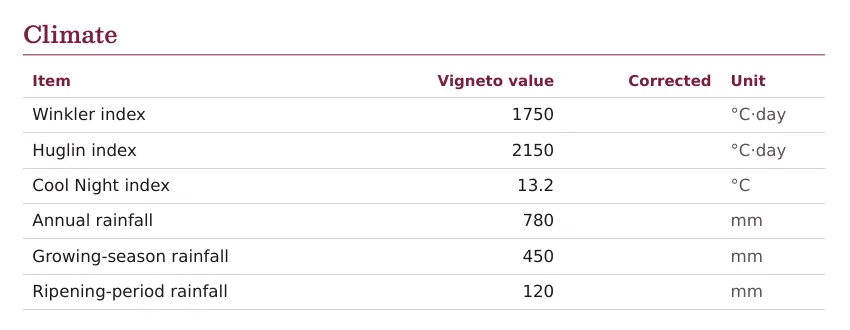
Climate indices, with units and reference period.
01 / Climate
The rhythm of the season
Accumulated warmth, cool nights before harvest and yearly rainfall describe how much and how well grapes can ripen.
Winkler and Huglin measure warmth useful to vines; Cool Night describes nights in the ripening month. Rainfall distinguishes the year, growing season and ripening period.
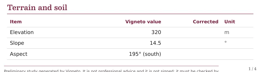
The shape of the terrain at the study site.
02 / Terrain
The shape that guides sun and water
Elevation, slope and aspect change temperature, light and drainage. Even two nearby slopes can tell a different story.
The Report records the values at the point and uses them, with the other data, to explain grape suitability.
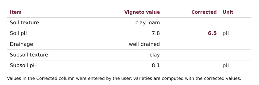
Topsoil and subsoil, with the original value beside the corrected one.
03 / Soil
What the roots encounter
Sand, silt and clay determine texture and water reserves. pH affects nutrients; drainage tells you how long moisture remains.
The document distinguishes topsoil from subsoil and clearly marks the values you have corrected.
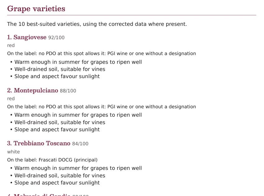
Grapes ranked by suitability, with reasons for each rating.
04 / Grape varieties
Not simply “yes” or “no”
Score, wine styles and reasons for the rating. See which conditions favour the grape and which make it struggle, with no black boxes.
Even the typical local grape may not come first: tradition does not alter the data.
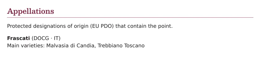
The appellations covering the point.
05 / Appellations
A link to the rules
The Report lists relevant PDOs, allowed grapes and a link to the European production rules.
The map helps you get your bearings, but the official rules always prevail.
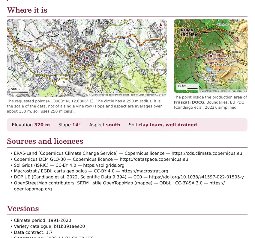
Maps at the beginning and sources at the end of the document.
06 / Maps and sources
Every number has a source
The area map and overview show where the point is. At the end you will find datasets, licences, climate period and versions used.
Climate, terrain and soil come from open data, with date and resolution always visible.
The method
Not just an answer. An explanation.
Good data should not leave you with just a number. It should help you understand. Vigneto connects climate, terrain and soil, one layer at a time.
01
Every number has a source
Climate, terrain and soil come from open datasets, with date, resolution and licence always visible.
02
Every rating has a reason
See which conditions favour the grape and which make it struggle, with no black boxes.
03
Every estimate has a limit
Vigneto guides research; it does not replace a site visit, laboratory analysis or an agronomist.
Inside the data
Three scales of landscape. One coherent reading.
From a valley's climate to the texture of the first few centimetres of earth. Vigneto connects information that normally lives on separate maps.
01 / Climate☀
The rhythm of the season
Accumulated warmth, cool nights before harvest and yearly rainfall describe how much and how well grapes can ripen.
Source
ERA5-Land · C3S / ECMWF
Period
1991–2020 averages
02 / Terrain⌁
The shape that guides sun and water
Elevation, slope and aspect change temperature, light and drainage. Even two nearby slopes can tell a different story.
Source
Copernicus DEM GLO-30
Detail
30-metre cells
03 / Soil≋
What the roots encounter
Sand, silt and clay determine texture and water reserves. pH affects nutrients; drainage tells you how long moisture remains.
The technician can correct climate, terrain and soil data with what they have measured or checked. Vigneto recalculates grape ratings after every correction.
The Report keeps Vigneto's value visible beside the corrected one: you can always reconstruct what changed.
Formats
Ready to read. And to edit.
The same study is available in two formats, without copying the data again.
PDF
To keep and share
A laid-out document with maps, tables, grapes, appellations, sources and data limitations.
Word
To use in your work
The editable DOCX format lets you check the contents and use them in your own document with your own tools.
Transparency
Clear data, informed choices.
A reliable tool does not promise certainty it cannot have. These are the limits to know before using an estimate.
Microclimate
A cell is not a vine row
Climate is an average over about 9 × 9 km, corrected for elevation. It does not see a single slope's microclimate or predict the future.
Soil
An estimate is not a laboratory
SoilGrids estimates soil over 250-metre cells. Lime is inferred from pH; drainage is estimated from texture and slope.
Suitability
Vines live on more than data
The model does not consider rootstock, the grower's work or field trials. Rules are calibrated on known areas, not agronomically validated.
Designations
A map does not replace the rules
European boundaries date to 4 November 2021 and often cover whole municipalities. Always check the official document before deciding.
The principle is simple: Vigneto helps you understand and get your bearings. It is not professional advice and does not replace a site visit, soil analysis or agronomist.
Plans
One study at a time, or several together.
Single report
A complete preliminary study of the site, in PDF and Word.
Report pack
Several Reports to use at different points, with the same maps, sources and correction options.
During the pilot they are free, by invitation. Prices will come after the pilot.
Report questions
Before you generate it.
What does the Report contain?
Climate, elevation, slope, aspect, texture, pH and drainage; grapes with scores and reasons; appellations, maps, notes and sources. Every technical term has a plain-language explanation.
Can I correct the data?
Yes. You can enter your climate, terrain and soil measurements. Grape ratings are recalculated and the Report keeps the initial value beside the corrected one.
Which formats can I download?
PDF and Word. The PDF is ready to keep and share; the DOCX is editable for your work.
Why isn't the typical grape always first?
The score looks at climate, terrain and soil, not tradition or vineyard work. A grape from another region can therefore be more suitable without diminishing the value of local cultivation.
Does Vigneto account for climate change?
It uses 1991–2020 averages, which include part of recent warming. It does not produce climate forecasts for the coming decades.
Is the Report signed by Vigneto?
No. It is a preliminary support study: the technician checks the results and signs their own document with their own tools.
The pilot
Try it on a place you know.
The pilot is free, by invitation: 10 reports and Projects for 10 weeks, in return for your expert perspective.